

By Nemanja Nikolic, Research Assistant and MPhil Candidate, City Futures Research Centre.
In an attempt to control the spread of the virus, state governments have gradually introduced various spatial measures and limitations in local hot-spot areas across the country. The goal of such restrictions is targeted at reducing people’s mobility and avoiding potential spill-overs to neighbouring areas. So far, these have included ‘stay at home orders’ for certain postcodes, suburbs or LGAs, combined with restrictions on travel of more than 10km – now 5km – beyond a person’s home LGA. But how effective have these measures been? Do they make sense from a scientific and governance perspective?
The use of spatial analysis/planning in epidemiology and medical geography has been well documented throughout history. Techniques such as cluster analysis or spatial autocorrelation are regularly employed to examine the spread of viruses (for instance cholera in the 19th century, by John Snow). One of the first pioneers of Town Planning, Sir Patrick Geddes, used medical analogies in establishing relationships between humans and their environment. Spatial analysis is not only used to understand spatial phenomena, but also to construct optimal planning solutions. For instance, how to place medical centres or fire stations in a way to achieve maximum population coverage, while minimising travel time?
In this context, the article focuses on the following questions:
- Do administrative boundaries reflect the way people actually live?
- Do the 5/10km limits present optimal travel distances as a COVID-19 prevention measure?
All travel distances have been computed using road network calculations, but are expressed in ‘as the crow flies’ straight lines distances – to make comparison with government guidelines easier.
Along imaginary lines
The initial response of state governments to the local spread of COVID-19 was to introduce hard borders and limit people’s mobility within specific jurisdictions. Even though these areas represent legal entities and make things easier from a governance perspective, in too many instances, they do not correspond to the way people live and work, nor do they reflect settlements and communities.
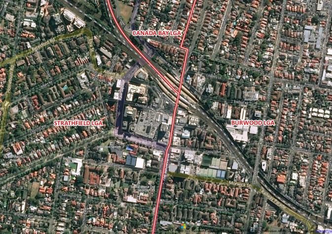
Figure 1: Strathfield Town Centre and train station – Split between three LGAs
This issue doesn’t stop with state boundaries (which are often, just arbitrary straight lines) but goes all the way down to city blocks, where streets separate suburbs in most impractical ways.
Figure 2: Suburb boundary between Mosman and Cremorne, along Spofforth Street
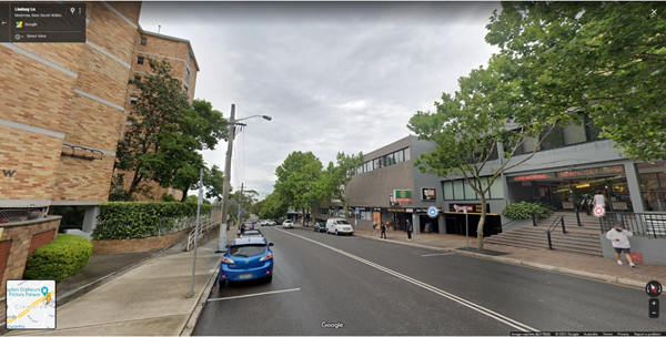
The example in Figure 2, shows how residents on the left-hand side of the street – officially part of the suburb of Mosman, in a hypothetical scenario of ‘hard borders’ wouldn’t be able to access the local supermarket, post office or medical centre just across the road – officially part of the suburb of Cremorne. The next closest substitute facilities are approximately 1.3km away. Over a period of six weeks, this represents a total of 110km of additional travel (if residents were to commute daily). Similar scenarios, although at a much larger magnitude, are seen at the QLD-NSW-VIC borders where workers require exemptions to access their usual place of work.
Functional Regions – a long term solution
So how can these issues be resolved? From a long-term perspective, the concept of Functional Regions (used by the OECD and EU amongst others – see OECD, 2013) provides a viable and practical solution. In essence, Functional Regions are self-contained areas that reflect the actual connections, interactions and flows that exist in space, based on specific human activities such as labour (Travel-to-work Area; see Mitchell and Stimson, 2010 for example in Australian context) or population movements (Daily Urban Systems). In most cases, there is a node/centre to which people gravitate toward and that provides certain services. This can be an employment centre or health and education cluster for instance (Brown and Holmes, 1971; Klapka et al., 2013). In the example above, the fact that residents’ shop and complete other daily activities in the local shopping centre (node) across the street, would be recognised and reflected in the boundaries.
Do LGAs in NSW reflect functional ties and movement? Well, only to a degree. As part of the colonial legacy – reflected in arbitrary straight-line boundaries, but also political factors – unwillingness of decision makers to follow through on change (when faced with potential voters’ backlash), LGAs remain limited in many ways. The most recent attempt at ‘optimisation’ was seen in 2015-16, when the NSW governments tried to reduce the number of LGAs from 152 to 112 via amalgamation. The process faced considerable controversy and local resistance (see ABC, 2015; 2016a; 2016b).
In a hypothetical scenario, the degree of optimal resident allocation (based on functional ties) was tested using a network analysis and compared to the actual allocation (established by the existing LGA boundaries). This was achieved, by calculating the shortest travel-time between each SA1 (smallest statistical unit) and its nearest major shopping centre, under free-flow traffic conditions. The number of potential destinations/shopping centres, was limited to 33 – matching the current number of LGAs in Metropolitan Sydney.
Figure 3: Optimal SA1 allocation, based on nearest major shopping centre
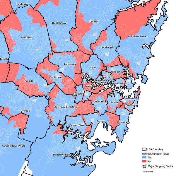
As seen on the map (in red), there is a significant number of areas that have sub-optimal allocation – i.e. the closest major shopping centre is outside of their designated LGA. This is especially pronounced along the edges of LGAs (see Cumberland and Canterbury-Bankstown, but also Inner-City areas such as Inner West and Canada Bay). In total, approximately 1,187,000 residents (or 25% of Metropolitan Sydney’s population) would need to travel more than usual, if LGA hard borders were implemented, to reach their largest shopping centre. An interesting example is also seen in Bayside, which is effectively ‘split in two’ by the Sydney Airport – acting as a barrier between the former Rockdale (West) and Botany Bay (East) LGAs. This is not to say that amalgamations are necessarily bad, but rather that border corrections need to be an outcome of careful analysis and support internal cohesion/accessibility.
10km and 5km zones – a short term solution?
To temporarily overcome the shortcomings imposed by existing administrative boundaries, state governments have introduced additional travel guidelines. These include buffer zones along state borders or more flexible arrangements currently seen in NSW, which allow local residents to travel up to 5km (previously 10km) outside of their LGA for a reasonable excuse (including shopping). Although these measures make life easier, at the same time they provide a ‘bridge’ for the virus to effectively spread across the metropolitan area, if the conditions are right.
Figure 4: 10km buffer zones across Metropolitan Sydney
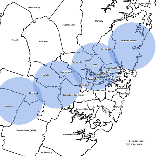
As seen in Figure 4, it would only take four people to spread COVID-19 from Camden to Northern Beaches (or the other way around). The darker shaded blue areas, between the buffers, represent overlap locations where transmission could potentially occur. Although this represents a highly unlikely scenario, the possibility of transmission increases substantially at micro-local scales and along borders, where the level of interaction is higher. In this context, each additional kilometre added, can dramatically change the chances for such an occurrence.
To better understand if the 5/10km radius is optimal in providing the necessary means for people to satisfy their basic needs, while minimising the chance of spread, an additional local network analysis was completed. Similarly, to the previous example, this was achieved by calculating the shortest travel-distance between each SA1 (smallest statistical unit) and its nearest local supermarket (compared to major shopping centre in previous example). The number of potential destinations/supermarkets (limited to Coles or Woolworths, because of data availability) was 263, with no limitations to number of destinations per LGA. The modelling was also used to locate residents that were likely to step-over LGA boundaries to reach their nearest supermarket (within the 5km radius) and hence identify potential areas of concern.
Figure 5: SA1 allocation to closest supermarket – Canterbury-Bankstown LGA
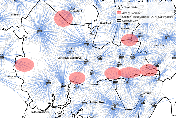
As seen in the example of Canterbury-Bankstown above and Figure 6, the Median Travel Distance (under the assumption that each resident used their closest supermarket and optimal travel route) was 1.2km, with 95% of residents reaching their destination within 3km. This represents a noticeably smaller distance to the current 5km limit enforced in hot-spot locations. Areas in the far South-East and East section of the LGA, along the border with Bayside, Georges River and Inner West represent potential areas of spread, as a significant proportion of Canterbury-Bankstown residents have their closest supermarket outside of the LGA boundary.
Figure 6 also points to two other important findings. Firstly, that most modelled trips (to the nearest supermarket) are well under the current 5km restrictions, providing room for further adjustments if the epidemiological situation were to worsen. Secondly, depending on the LGA location and urban form, the modelled travel distance varied substantially, requiring different approaches depending on the context – i.e. densely populated (Inner-City) LGAs have much smaller distances compared to outer metropolitan LGAs. Allowing for additional leeway in these dense areas, could lead to easier spread.
Figure 6: Summary statistics of modelled travel distances to nearest supermarket by LGA
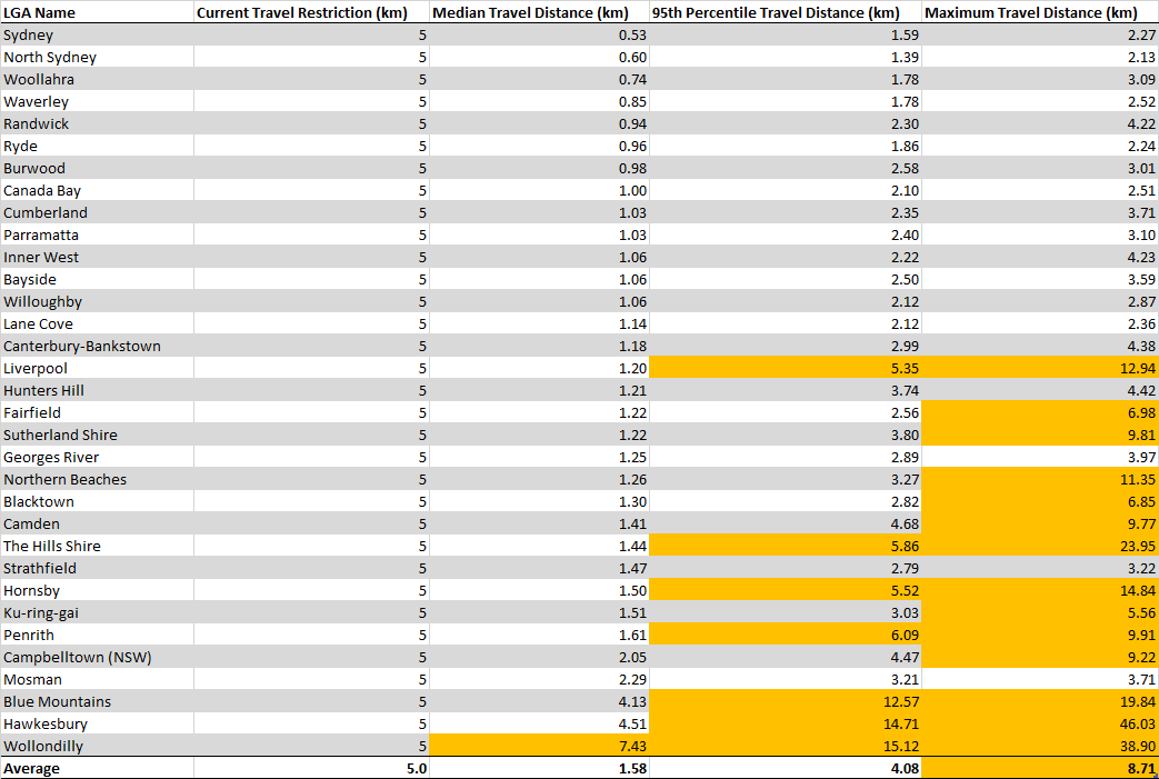
Note: The cells in orange have larger modelled travel distances to current restrictions
Conclusions
Functional Regions and an informed approach to travel restrictions, provide a platform to achieve better community outcomes while minimising the chances of COVID-19 spill-overs. This requires a combination of long and short-term planning, that accounts for the whole spectrum of interactions and flows between people and the environment (including local idiosyncrasies) and is ideally reflected in LGA/administrative boundaries. Further research is also needed into the hierarchy of human needs – i.e. establishing an objective ranking to which activities take priority, and the travel distances needed to achieve them. This would allow for a set of measures, that could be applied depending on the spatial context and virus circulation – i.e. 2.5km for essential activities (high virus circulation), 5km for discretionary shopping (medium virus circulation) in inner-urban LGAs etc. Governments could also ‘designate’ each household a unique local supermarket (informed by network modelling) and notify them by mail, effectively reducing the number of potential exposure sites and making contact tracing easier. Lastly a better understanding of which category of places lead to the virus spread – the findings of Praharaj and Han (2020), suggest this is grocery and retail – could further complement the findings and inform the adequate response.
Note: The NSW Health Department and the Office of Brad Hazzard were asked to provide insight on the 4th of August 2020, to the process that informed the current 5km radius measures. No response was received, till date. It is the belief of the author that greater transparency is needed.
References
ABC. (2015). NSW councils to merge under State Government plan for forced amalgamations; 2016 elections delayed. https://www.abc.net.au/news/2015-12-18/sydney-councils-to-be-forced-to-merge-by-nsw-government/7039326
ABC. (2016a). Local council amalgamations: Decision imminent as NSW Cabinet considers issue. https://www.abc.net.au/news/2016-05-12/nsw-local-council-merger-announcement-imminent/7406790
ABC. (2016b). NSW council amalgamations: 19 new local bodies created under forced mergers. https://www.abc.net.au/news/2016-05-12/new-councils-created-under-forced-mergers-across-nsw/7408152
Brown, L. A. and Holmes, J. (1971). The Delimitation of Functional Regions, Nodal Regions, and Hierarchies by Functional Distance Approaches. Ekistics, pp. 387-391.
Klapka, P., Halas, M., Tonev, P. and Bednar, M. (2013). Functional Regions of the Czech Republic: Comparison of Simpler and More Advanced Methods of Regional Taxonomy. Acta Universitatis Palackianae Olomucensis–Geographica, 44 (1), 45-57.
Mitchell, W. F. and Stimson, R. (2010). Creating a new geography of functional economic regions to analyse aspects of labour market performance in Australia. Callagan, Australia: Centre of Full Employment and Equity, University of Newcastle.
OECD. (2013). Definition of Functional Urban Areas (FUA) for the OECD Metropolitan Database. Organization for Economic Cooperation and Development website.
Praharaj, S., & Han, H. (2020). A longitudinal study of the impact of human mobility on the incidence of COVID-19 in India. medRxiv.
No Comments so far ↓
There are no comments yet...Kick things off by filling out the form below.